

Open User Map
Open User Map lets you add a collaborative, customizable map to your WordPress site where visitors submit and edit locations without coding.
AI tool Details
Explore More
Alternatives
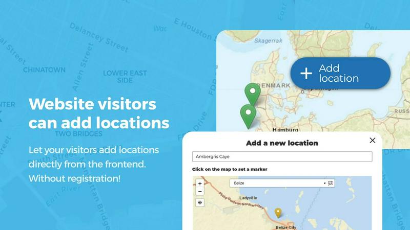
About Open User Map
Open User Map is a powerful, user-friendly WordPress plugin that transforms a simple map into an interactive, community-driven tool. It allows website visitors to add, edit, and interact with locations directly on a map, all without any coding knowledge, a Google Maps API key, or complex setup. The plugin is designed for anyone who wants to build a collaborative map experience, from local business directories and event planners to tourism boards and community groups. Its core value proposition is simplicity: you can have a fully functional, crowdsourced map live on your site in minutes. The plugin handles all the technical heavy lifting, including frontend submissions, approval workflows, and powerful customization options. With over 15,000 active installs and a 100% five-star rating on WordPress.org, it is the number two map plugin on the platform. Open User Map offers both a free version and a PRO version, with the PRO trial available for seven days with no credit card required. This makes it an accessible and risk-free solution for anyone looking to add dynamic, user-generated map content to their website, enhancing engagement and providing up-to-date information without constant manual updates.
Features
Frontend Location Submissions and Editing
Enable your website visitors to add and edit locations directly on your map. By clicking an 'Add location' button, users can place a marker, fill out details, and submit it for your approval before it goes live. The editing capability allows users to update their existing locations, ensuring the map always reflects the most current information. This feature streamlines data collection and keeps your map fresh without requiring backend management from you.
Categorization and Filtering
Organize your map more effectively by grouping locations into marker categories, each distinguished by unique icons. This setup not only clarifies the map's layout but also allows visitors to filter through different types of locations. For added flexibility, each location can belong to multiple categories, ensuring that all relevant attributes are represented and easily accessible by users. This makes navigation intuitive and content discovery effortless.
Lines and Areas
Go beyond simple location markers by adding routes, paths, zones, and regions directly to your map. Lines and Areas lets you highlight trails, service areas, event grounds, neighborhoods, construction zones, or any custom shape that helps visitors understand your map at a glance. Distances and area sizes are calculated automatically, so routes and polygons can include helpful measurements right out of the box, providing a richer, more informative map experience.
Custom Image as Map
Upload any image and transform it into a fully interactive map, whether it is an overlay, floor plan, event layout, game map, product diagram, campus guide, or seating chart. Users can place markers directly on top of it with the same powerful functionality as a traditional map. You can add locations, display custom fields, enable filtering, and create an engaging, clickable experience tailored exactly to your use case, opening up endless creative possibilities.
Advanced Filter Interface
Create a filter sidebar that appears next to your map, allowing visitors to filter locations by any custom field you have configured. You can also add custom HTML content sections to display additional information or branding. This gives users a clearer, more intuitive way to explore your mapped data, making it easy to find exactly what they are looking for while maintaining a professional and branded look.
Flexible Custom Fields
Enhance your map with tailored custom fields, adding text boxes, links, checkboxes, and dropdowns to suit your specific needs. This feature allows you to gather exactly the information you require from map interactions, making your data collection as comprehensive and user-specific as possible. Whether you need opening hours, contact info, or special notes, custom fields make it happen seamlessly.
Community Interaction with Upvotes and Star Ratings
Allow your visitors to upvote or like locations to help you highlight the best places or flag inappropriate content. For more detailed feedback, you can enable a full 1-5 star rating system. These community-driven features are perfect for highlighting top-rated spots and fostering engagement, ensuring that the best locations naturally rise to the top based on user input.
Opening Hours with Live Indicators
Display beautifully styled business hours including a live "Open Now" indicator based on the current time. This feature is perfect for directories and local business listings, providing visitors with immediate, actionable information about whether a location is currently open. It adds a layer of real-time utility that enhances the user experience and drives foot traffic to active businesses.
Use Cases
Local Business and Service Directories
Create a community-driven directory where locals and visitors can add and review businesses, restaurants, and services. Users can submit new locations, update hours, and leave star ratings, while you maintain control through an approval workflow. The opening hours feature with a live "Open Now" indicator ensures users always know where to go. This creates a dynamic, self-sustaining resource that stays accurate without constant manual updates.
Event and Festival Planning
Use Open User Map to build an interactive map for events, festivals, or conferences. Attendees can add their own meetup points, vendors can mark their booths, and organizers can draw lines for parade routes or areas for specific activities. The custom image as map feature is perfect for overlaying a schematic of an event layout. This turns a static map into a living, collaborative tool that enhances attendee experience and logistics.
Tourism and Travel Guides
Develop a comprehensive travel guide map where tourists and locals can contribute points of interest like hidden gems, hiking trails, viewpoints, and landmarks. The lines and areas feature is ideal for marking hiking paths or scenic zones, while categories and filtering let users explore by activity type. User upvotes and reviews help highlight the best spots, creating an authentic, crowdsourced travel resource that is always evolving.
Community and Neighborhood Projects
Empower residents to map local resources, from community gardens and public art to dog parks and recycling centers. The regions feature allows you to define neighborhoods or districts, while users can submit and edit locations within their area. Approval workflows ensure quality control, and the ability to add custom fields lets you collect specific data like maintenance schedules or contact info. This fosters a sense of community ownership and keeps local information accurate.
Frequently Asked Questions
Do I need coding skills or a Google Maps API key to use Open User Map?
No, you do not need any coding skills or a Google Maps API key to use Open User Map. The plugin is designed for ease of use, with a simple setup process that can be completed in minutes. It handles all the technical requirements, including map rendering and API integration, so you can focus on building your map content.
Can visitors add and edit locations on my map?
Yes, Open User Map allows website visitors to add and edit locations directly on the map. They can place markers, submit details, and even edit their existing submissions. However, all submissions go through an approval workflow, meaning you have full control over what gets published, ensuring quality and accuracy.
What types of map features can I include beyond simple markers?
Beyond standard location markers, Open User Map supports lines and areas for routes, paths, zones, and regions. You can also upload a custom image to use as a map, such as a floor plan or event layout. Additionally, you can create advanced filter sidebars and add custom fields like text boxes, checkboxes, and opening hours with live status indicators.
Is there a free version of Open User Map available?
Yes, there is a free version of Open User Map available for download on WordPress.org. It includes core features like location submissions, categories, and basic customization. For advanced features like custom image maps, advanced filters, upvotes, star ratings, and opening hours, you can try the PRO version with a 7-day free trial that requires no credit card and does not auto-renew into a paid subscription.
Similar to Open User Map

Built2Win AI Indexing
Custom PHP websites, AI Indexing Pack ($599 one‑time), and WebAgentScan SaaS ($9/mo). MCP, A2A, llms.txt, full ownership.

Webleadr
Webleadr helps you effortlessly find and contact web design leads and businesses without websites in just a few clicks from anywhere.

Idearium
Idearium crafts high-performing websites that drive growth and deliver measurable results.

FilexHost
Effortlessly host and share any file with a simple drag and drop, getting a shareable link in seconds.

Crawlkit
Crawlkit is a simple API that turns any website into structured data with one call.
Best Boilerplates
Find and compare SaaS boilerplates to launch your app faster.

Shadcn UI Kit
Accelerate your web development with Shadcn UI Kit's ready-to-use dashboards, templates, and components for React.

Clio Websites
Clio Websites builds custom, mobile-first sites that attract customers and grow your business.